Sidebar

Weather

"Initials" by "Florian Körner", licensed under "CC0 1.0". / Remix of the original. - Created with dicebear.comInitialsFlorian Körnerhttps://github.com/dicebear/dicebearWE
Weather ingalls 3 weeks ago 100%
Fallstreak hole I saw this morning
7
0
"Initials" by "Florian Körner", licensed under "CC0 1.0". / Remix of the original. - Created with dicebear.comInitialsFlorian Körnerhttps://github.com/dicebear/dicebearWE
Weather ingalls 3 weeks ago 100%
Some snow this morning in the higher elevations of Montana https://lemmy.today/pictrs/image/c420b2ff-ce2b-40ef-ba9c-ad3d9742c8ba.png
28
0
"Initials" by "Florian Körner", licensed under "CC0 1.0". / Remix of the original. - Created with dicebear.comInitialsFlorian Körnerhttps://github.com/dicebear/dicebearWE
Weather ingalls 4 weeks ago 88%
Nevada frost advisories are another sign of autumn‘s approach ingallswx.com
7
1
"Initials" by "Florian Körner", licensed under "CC0 1.0". / Remix of the original. - Created with dicebear.comInitialsFlorian Körnerhttps://github.com/dicebear/dicebearWE
Weather ingalls 4 weeks ago 100%
T-storm chances for Pacific Northwest on Friday ingallswx.com
7
0
"Initials" by "Florian Körner", licensed under "CC0 1.0". / Remix of the original. - Created with dicebear.comInitialsFlorian Körnerhttps://github.com/dicebear/dicebearWE
Weather ingalls 1 month ago 100%
Bering Sea storm brings erosion and flooding to Western Alaska communities alaskapublic.org
7
0
"Initials" by "Florian Körner", licensed under "CC0 1.0". / Remix of the original. - Created with dicebear.comInitialsFlorian Körnerhttps://github.com/dicebear/dicebearWE
Weather ingalls 1 month ago 100%
T-storms possible near and west of the Cascades this weekend ingallswx.com
9
0
"Initials" by "Florian Körner", licensed under "CC0 1.0". / Remix of the original. - Created with dicebear.comInitialsFlorian Körnerhttps://github.com/dicebear/dicebearWE
Weather ingalls 1 month ago 100%
How to read surface weather analysis maps ingallswx.com
6
0
"Initials" by "Florian Körner", licensed under "CC0 1.0". / Remix of the original. - Created with dicebear.comInitialsFlorian Körnerhttps://github.com/dicebear/dicebearWE
Weather ingalls 1 month ago 100%
What does the South Pole Stratospheric Warming mean for Winter 2024/2025? www.severe-weather.eu
10
0
"Initials" by "Florian Körner", licensed under "CC0 1.0". / Remix of the original. - Created with dicebear.comInitialsFlorian Körnerhttps://github.com/dicebear/dicebearWE
Weather ingalls 2 months ago 100%
Moisture from Debby being pulled up to Newfoundland
12
1
"Initials" by "Florian Körner", licensed under "CC0 1.0". / Remix of the original. - Created with dicebear.comInitialsFlorian Körnerhttps://github.com/dicebear/dicebearWE
Weather ingalls 2 months ago 100%
Record Heat and Wildfires for the Western U.S. charliephillips.me
17
0
"Initials" by "Florian Körner", licensed under "CC0 1.0". / Remix of the original. - Created with dicebear.comInitialsFlorian Körnerhttps://github.com/dicebear/dicebearWE
Weather ingalls 2 months ago 97%
Sahara dust plume over the Atlantic around 13z Wednesday
39
5
"Initials" by "Florian Körner", licensed under "CC0 1.0". / Remix of the original. - Created with dicebear.comInitialsFlorian Körnerhttps://github.com/dicebear/dicebearWE
Weather ingalls 2 months ago 100%
7 tornadoes observed in Chicagoland, drone footage shows major damage from Monday night’s powerful storms https://wgntv.com/news/chicago-news/watch-7-tornadoes-confirmed-in-chicagoland-drone-footage-shows-major-damage-from-monday-nights-powerful-storms/
14
0
"Initials" by "Florian Körner", licensed under "CC0 1.0". / Remix of the original. - Created with dicebear.comInitialsFlorian Körnerhttps://github.com/dicebear/dicebearWE
Weather ingalls 2 months ago 100%
Smoke season is underway in the Inland Northwest
22
1
"Initials" by "Florian Körner", licensed under "CC0 1.0". / Remix of the original. - Created with dicebear.comInitialsFlorian Körnerhttps://github.com/dicebear/dicebearWE
Weather ingalls 2 months ago 100%
Weak rain shower keeps Boise from 100°F (38°C) yesterday, prematurely ending their streak

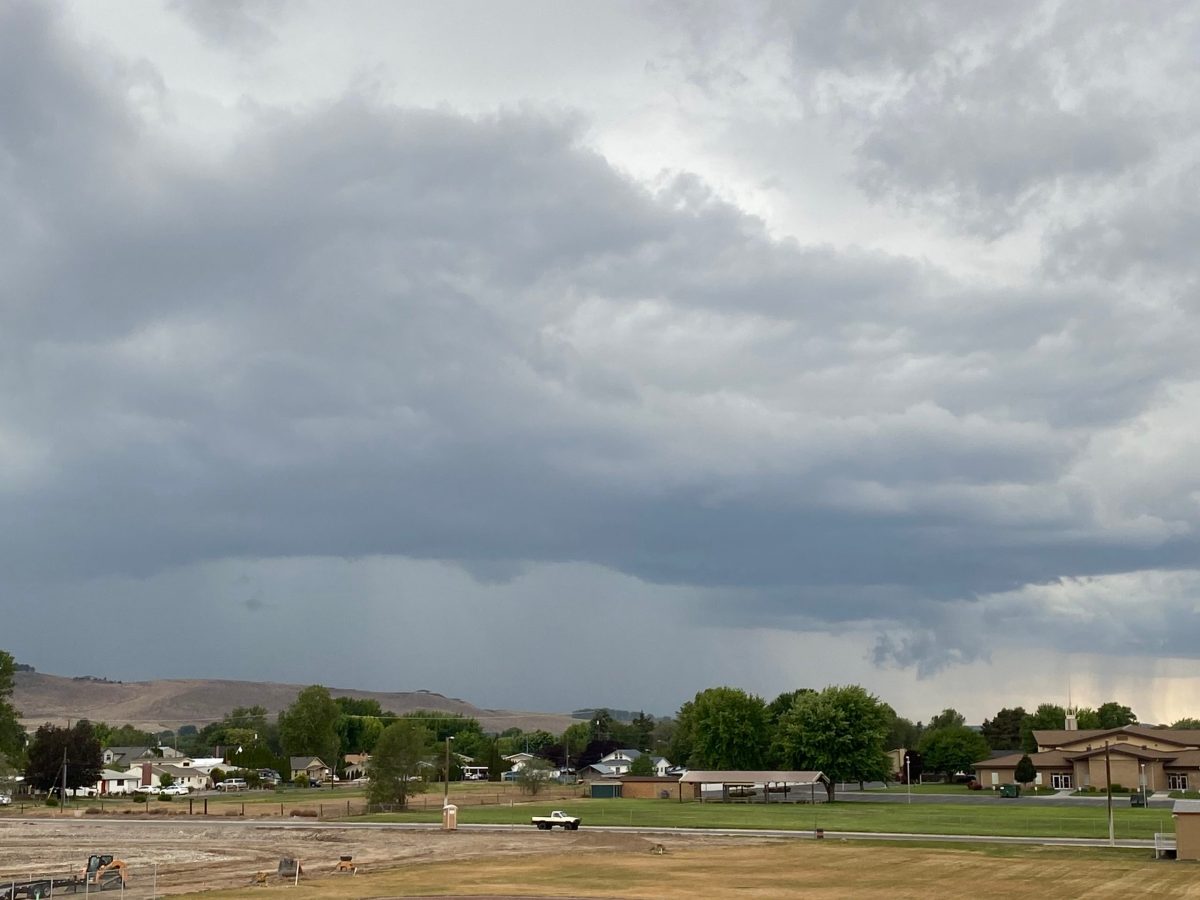
Boise, Idaho is in a long-lasting heatwave but after six days above 100° they fell just short of that threshold and have to restart to see if they can break the record of nine consecutive 100° days in a row.

13
2
"Initials" by "Florian Körner", licensed under "CC0 1.0". / Remix of the original. - Created with dicebear.comInitialsFlorian Körnerhttps://github.com/dicebear/dicebearWE
Weather homesweethomeMrL 4 months ago 88%
50% Chance https://lemmy.world/pictrs/image/9622a732-2df2-438e-b3f5-6278a5b5dc60.jpeg
55
12
"Initials" by "Florian Körner", licensed under "CC0 1.0". / Remix of the original. - Created with dicebear.comInitialsFlorian Körnerhttps://github.com/dicebear/dicebearWE
Weather Ultragigagigantic 5 months ago 98%
PSA https://lemmy.world/pictrs/image/48768ede-a709-4d64-ae6f-f7006006c485.jpeg
268
7
"Initials" by "Florian Körner", licensed under "CC0 1.0". / Remix of the original. - Created with dicebear.comInitialsFlorian Körnerhttps://github.com/dicebear/dicebearWE
Weather ki77erb 1 year ago 100%
More tornadoes in Eastern Colorado (8/8/23)
7
0
"Initials" by "Florian Körner", licensed under "CC0 1.0". / Remix of the original. - Created with dicebear.comInitialsFlorian Körnerhttps://github.com/dicebear/dicebearWE
Weather Shdwdrgn 1 year ago 100%
Are there any communities for personal weather stations?

Just curious if any such communities exist here. I built a DIY weather station from 3D prints and an ESP 8266, always looking for improvements on the design, but after a massive downpour yesterday I'm also looking for tips on more accurately calibrating my rain gauge.

4
0
"Initials" by "Florian Körner", licensed under "CC0 1.0". / Remix of the original. - Created with dicebear.comInitialsFlorian Körnerhttps://github.com/dicebear/dicebearWE
Weather Stanwich 1 year ago 100%
Evening sun prince george bc July 13
3
0
"Initials" by "Florian Körner", licensed under "CC0 1.0". / Remix of the original. - Created with dicebear.comInitialsFlorian Körnerhttps://github.com/dicebear/dicebearWE
Weather ki77erb 1 year ago 100%
Tracking tornadoes in Southern Colorado

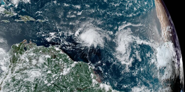
Some great storm chasers on the ground right now. https://www.youtube.com/live/jJ9nLn4HeZg?feature=share

1
0
"Initials" by "Florian Körner", licensed under "CC0 1.0". / Remix of the original. - Created with dicebear.comInitialsFlorian Körnerhttps://github.com/dicebear/dicebearWE
Weather ki77erb 1 year ago 100%
Thunderstorms in the distance

This is the outer edge of what's left of a thunderstorm in Virginia Beach.

3
0
"Initials" by "Florian Körner", licensed under "CC0 1.0". / Remix of the original. - Created with dicebear.comInitialsFlorian Körnerhttps://github.com/dicebear/dicebearWE
Weather m3t00 1 year ago 100%
12 Hour Surface Forecast | Surface Analysis Maps | Weather Underground https://www.wunderground.com/maps/surface-analysis/12hr

24 36 48 hour links, bottom of page. fronts labeled
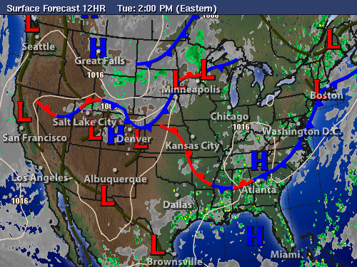
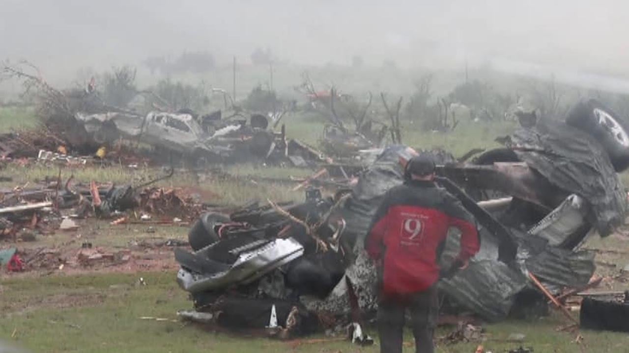
 ![](https://lemmy.world/pictrs/image/baeb0135-9577-41e9-a2dc-de22a384bd41.png)

1
0
"Initials" by "Florian Körner", licensed under "CC0 1.0". / Remix of the original. - Created with dicebear.comInitialsFlorian Körnerhttps://github.com/dicebear/dicebearWE
Weather DocMcStuffin 1 year ago 100%
The Atlantic tropics are on fire—it already looks like August out there arstechnica.com
1
0
"Initials" by "Florian Körner", licensed under "CC0 1.0". / Remix of the original. - Created with dicebear.comInitialsFlorian Körnerhttps://github.com/dicebear/dicebearWE
Weather ki77erb 1 year ago 100%
Large Tornado hits Matador, TX (6-22-23) www.news9.com

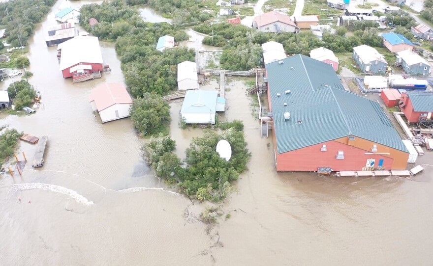
I was watching this on the radar last night and just saw the reports this morning of the damage. Very sad situation in Matador right now. Video of storm chasers pulling someone from the rubble shortly after it passed. https://www.youtube.com/watch?v=3-Rc9OBs7Bk

1
0
"Initials" by "Florian Körner", licensed under "CC0 1.0". / Remix of the original. - Created with dicebear.comInitialsFlorian Körnerhttps://github.com/dicebear/dicebearWE
Weather m3t00 1 year ago 100%
90 hot at my house today https://www.wunderground.com/forecast/us/il/east-peoria/40.67,-89.59

wunderground 10 day graph 61611

1
0
"Initials" by "Florian Körner", licensed under "CC0 1.0". / Remix of the original. - Created with dicebear.comInitialsFlorian Körnerhttps://github.com/dicebear/dicebearWE
Weather Reddit_was_fun 1 year ago 100%
Tropical Depression 3 (soon to be TS Bret) has formed. Could be the earliest formed hurricane in 11 years. https://i.imgur.com/Zef4yAK.jpg
1
0
"Initials" by "Florian Körner", licensed under "CC0 1.0". / Remix of the original. - Created with dicebear.comInitialsFlorian Körnerhttps://github.com/dicebear/dicebearWE
Weather m3t00 1 year ago 100%
North Bossier https://lemmy.world/pictrs/image/cfe86530-aa24-4501-b7c4-df59d9e6196f.png

storm front #wx https://www.facebook.com/photo/?fbid=831352275016494&set=a.263683615116699

2
0
"Initials" by "Florian Körner", licensed under "CC0 1.0". / Remix of the original. - Created with dicebear.comInitialsFlorian Körnerhttps://github.com/dicebear/dicebearWE
Weather intelati 1 year ago 100%
Here we go proper in the Atlantic

Cherry (90%) Tropical system

1
0
"Initials" by "Florian Körner", licensed under "CC0 1.0". / Remix of the original. - Created with dicebear.comInitialsFlorian Körnerhttps://github.com/dicebear/dicebearWE
Weather ki77erb 1 year ago 100%
Huge shelf cloud in Virginia Beach 6-16-23 https://lemmy.world/pictrs/image/b435915a-50dd-4e42-a4c9-3628532b8e09.jpeg

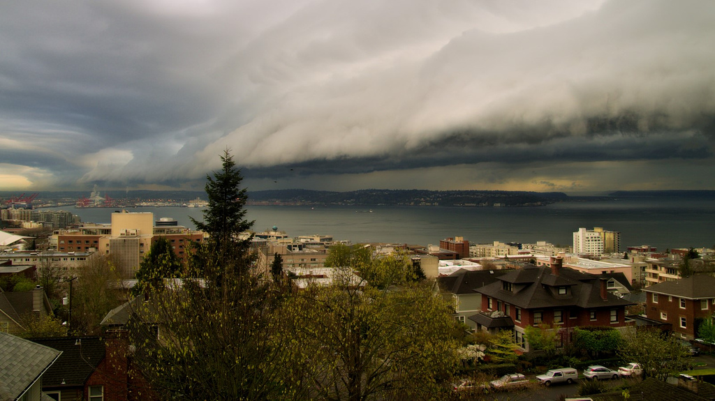
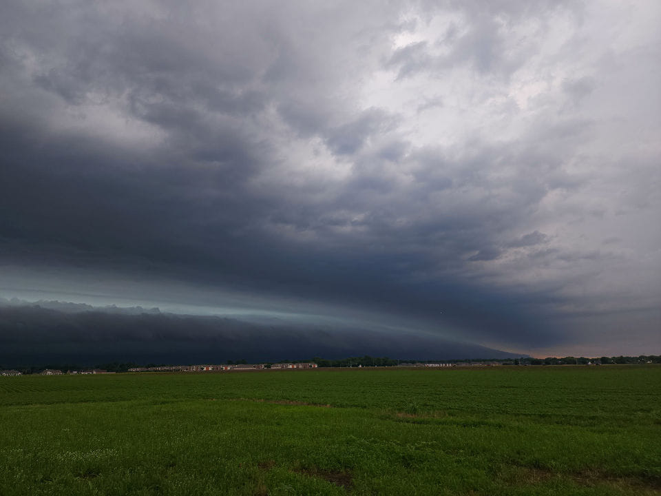
I took this picture of a huge shelf cloud that moved in fast over Virginia Beach yesterday. Several tornado warnings and hail in the area as well.

1
0
"Initials" by "Florian Körner", licensed under "CC0 1.0". / Remix of the original. - Created with dicebear.comInitialsFlorian Körnerhttps://github.com/dicebear/dicebearWE
Weather intelati 1 year ago 100%
Day 1 Hazardous Weather Outlook: Monster hail in OK

SPC AC 170600 Day 1 Convective Outlook NWS Storm Prediction Center Norman OK 0100 AM CDT Sat Jun 17 2023 Valid 171200Z - 181200Z ...THERE IS AN ENHANCED RISK OF SEVERE THUNDERSTORMS ACROSS PARTS OF THE SOUTHERN AND CENTRAL PLAINS... ...SUMMARY... Severe thunderstorms associated with damaging wind gusts and large hail are expected to develop this afternoon and evening across the southern and central Plains. Wind gusts above 70 knots and hailstones greater than 2 inches in diameter will be possible. The severe threat could reach the Ark-La-Tex after midnight. Isolated to scattered severe thunderstorms are also expected in Florida, and along parts of the central and eastern Gulf Coast. ...Central and Southern Plains... A shortwave trough will move across the southern and central Rockies today towards a moist and unstable airmass in the southern and central Plains. At the surface, a low will deepen in west Texas near a dryline that will extend northward into eastern Colorado. Low-level convergence will increase along the dryline as surface temperatures warm during the day. This should result in convective initiation in the vicinity of the Palmer Divide during the early afternoon. The convection is forecast to expand in coverage, and develop into an MCS during the late afternoon and early evening. The MCS is forecast to track east-southeastward from southeast Colorado into southern Kansas and Oklahoma. A 45 to 60 knot mid-level jet associated with the shortwave trough, is forecast to move eastward into the southern High Plains today. Ahead of this feature, a moist and very unstable airmass will be in place form the Texas Panhandle extending east-southeastward across much of Oklahoma and northeast Texas. Surface dewpoints from the mid 60s to lower 70s F will contribute to moderate to strong instability by afternoon, with MLCAPE likely reaching the 3000 to 5000 J/kg range. In addition to an impressive thermodynamic environment, kinematics will improve during the day as the mid-level jet approaches. By late afternoon, RAP forecast soundings along the track of the expected MCS have supercell wind profiles, with 0-6 km shear around 50 knots. This, combined with 700-500 mb lapse rates near 8.0 C/km will be very favorable for large hail. Hailstones of greater than 2 inches in diameter will be possible with the more intense supercells, associated with discrete cells that develop ahead of the track of the MCS. A tornado, wind-damage and hail threat is also expected to develop with supercells embedded within the MCS. The greatest tornado threat is forecast in northwest Oklahoma, where low-level shear will steadily ramp up during the early to mid evening. As the MCS organizes and moves southeastward into the strong instability, supercells and bowing line segments are expected. The wind-damage potential will likely increase during the early to mid evening as the MCS accelerates east-southeastward in the southern Plains. Wind gusts above 70 knots will become possible with cells near the leading edge of the MCS during the evening. The linear MCS is expected to move across central Oklahoma by late evening, and could reach the western Ozarks or Ark-La-Tex during the overnight period. ...Central and Eastern Gulf Coast into Florida... An upper-level trough will move southeastward across the eastern Gulf Coast states today. At the surface, a moist airmass will be in place from the central Gulf Coast eastward to Florida where dewpoints will be from the upper 60s to the mid 70s F. It appears that an outflow boundary will be in place in southern Mississippi and southern Alabama, where low-level convergence will become maximized during the day. As surface temperatures warm near this boundary, thunderstorms are expected to form around midday. These storms will move southeastward toward the immediate coastal areas with a severe threat likely developing. RAP forecast soundings this afternoon from Biloxi, Mississippi eastward into the Florida Panhandle have MLCAPE peaking in the 3000 to 4000 J/kg range, with steep lapse rates between 700 and 500 mb. This, combined with 0-6 km shear in the 40 to 50 knot range should support supercell development with isolated large hail. Hailstones of greater than 2 inches in diameter will be possible with the more intense cells. A wind-damage threat will also be likely. Further east across Florida, a moist airmass will be in place with surface dewpoints in the 70s F. Thunderstorm development will take place along sea-breeze boundaries as temperatures warm during the day. A few thunderstorms will also develop further inland. RAP forecast soundings in central Florida have MLCAPE peaking around 3000 J/kg, with 0-6 m shear in the 30 to 35 knot range. This, combined with steep low-level lapse rates should be enough for an isolated wind-damage threat. Hail will also be possible with the stronger cells. ..Broyles/Jirak.. 06/17/2023

1
0
"Initials" by "Florian Körner", licensed under "CC0 1.0". / Remix of the original. - Created with dicebear.comInitialsFlorian Körnerhttps://github.com/dicebear/dicebearWE
Weather intelati 1 year ago 100%
Android (and iOS) Weather app (wX and wXL23)

If you're on Lemmy and Weather community at that, then you need to be looking at more than just the NWS 7 day forecast. This app has the seven day forecast, discussion, SPC, NHC, and all the models you can shake a stick at. Here's his [GitLab](gitlab.com/joshua.tee/wx/). Found on Play Store (wX) and App Store (wXL23)

1
0
"Initials" by "Florian Körner", licensed under "CC0 1.0". / Remix of the original. - Created with dicebear.comInitialsFlorian Körnerhttps://github.com/dicebear/dicebearWE
Weather ki77erb 1 year ago 100%
Desktop Weather App currently in development

I posted this as a comment but thought it might be helpful to share it here as well. I recently stumbled on a project that is in development. It’s called “Supercell WX” and it’s awesome! Currently on Pre-release 3. Includes Level 3 and Level 2 data, multi-pane views and much more. It's similar to GR2 but obviously still in the early stages. Some links below but you should definitely check it out. Website: https://supercell-wx.readthedocs.io/en/latest/# Discord for development discussion: https://discord.gg/S2jxNMfG (it says this link expires in 7 days?) Github to download the program: https://github.com/dpaulat/supercell-wx/releases

1
0
"Initials" by "Florian Körner", licensed under "CC0 1.0". / Remix of the original. - Created with dicebear.comInitialsFlorian Körnerhttps://github.com/dicebear/dicebearWE
Weather m3t00 1 year ago 100%
Weather Radar | Weather Underground https://www.wunderground.com/radar/us

#wx #radar loop

1
0